Filtrer les publications
Sea level estimation from SNR data of geodetic receivers using wavelet analysis
Previous studies have proved that commercial, off-the-shelf, geodetic-quality Global Positioning System (GPS) receivers can monitor water level using multipath interferometric characteristics from the sea surface. A Lomb–Scargle periodogram (LSP) is typically used to extract the multipath frequency from the signal-to-noise ratio (SNR), which relates to the vertical distance between the antenna phase center and the reflecting surface, and subsequently, estimate sea levels.
X. Wang, Q. Zhang, S. Zhang
GPS Solutions, volume 23, article 6
Sedimentary Dynamics and Decadal-Scale Changes in the Macrotidal Aulne River Estuary, Brittany, France
Studies of macrotidal estuaries have been dominated by large, high-turbidity systems like the Gironde and Severn, but some macrotidal estuaries are different from these systems. The goal of this study was to document the state of hydrosedimentary processes in the macrotidal, low-turbidity Aulne River estuary and, where possible, compare it to a previous study. Study sites from a 1977 study were revisited in 2013. Observations of velocity, salinity, and suspended sediment concentration were analyzed and compared to the 1977 study, with particular attention given to hourly data.
S. Moskalski, F. Floc'h, R. Verney, G. Fromant, N. Le Dantec, A. Deschamps
Journal of Coastal Research, volume 34
Time variability of hydrodynamics and potential use of surface water and ocean topography mission in estuarine macrotidal system: example of Seine estuary
L. Chevalier, B. Laignel, I. Turki, F. Lyard, C. Lion
Journal of Applied Remote Sensing, volume 12

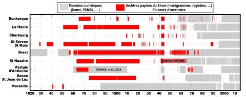
Intérêt du "Data-Rescue" en marégraphie : des archives papiers à l’étude de l’évolution du niveau marin. Exemple de la reconstruction de la série marégraphique de Saint-Nazaire depuis le 19ème siècle
La hausse du niveau de la mer liée aux changements climatiques globaux demeure l'une des préoccupations sociétales majeures. L'analyse des données marégraphiques, constituant souvent les seules informations disponibles à l’échelle des décennies, voire des siècles passés, se révèle être un moyen idéal pour parvenir à dégager des tendances sur le long terme. Or, malgré un patrimoine historique marégraphique français conséquent, la majorité de ces mesures est encore sous forme papier et n’est donc pas exploitée.
Y. Ferret Y., S. Lorrette-Riberolles, V. Donato, N. Pouvreau
Paralia - XVèmes Journées Nationales Génie Côtier - Génie Civil, La Rochelle
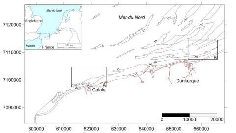
Évolution du rivage et des petits-fonds du littoral du Nord de la France depuis le 19ème siècle
La façade nord des Hauts-de-France correspond à une frange côtière de 60 km orientée OSO-ENE ouverte sur la mer du Nord. De nombreux bancs sableux sont présents le long de ce littoral où ils forment des corps sédimentaires massifs parallèles à obliques au trait de côte, localisés sur l’avant-côte jusqu’à plusieurs dizaines de mètres de profondeur. Des levés bathymétriques ont été exécutés depuis les années 1830 dans cette région. Les résultats de ces levés hydrographiques sont conservés au format papier dans les archives du Shom.
A. Latapy, A. Hequette, N. Pouvreau, N. Weber
Paralia - XVème Journées Nationales Génie Côtier – Génie Civil, La Rochelle
Relative Contribution of Wave Setup to the Storm Surge: Observations and Modeling Based Analysis in Open and Protected Environments (Truc Vert beach and Tubuai island)
Recent events like the Xynthia (2010, France) storm illustrate the potentially devastating effect that storm surges can have on the coasts. Nearshore storm surges at the result mainly from two processes: atmospheric surges and wave setup. This paper investigate the relative wave setup contribution in the storm surge signal for energetic events and focusing on two cases: an open beach (Truc Vert beach, France) and a high island protected by a reef lagoon (Tubuai, French Polynesia).
R. Pedreros, D. Idier, H. Muller, S. Lecacheux, F. Paris, M. Yates-Michelin, F. Dumas, L. Pineau-Guillou, N. Sénéchal
Journal of Coastal Research, Special Issue 85 - Proceedings of the 15th International Coastal Symposium, pp1046–1050

Assessment of Flooding Hazards at An Engineered Beach during Extreme Events: Biarritz, SW France
This study focuses on flooding hazards along the Grande Plage of Biarritz. This pocket engineered beach, located in the south west of France, was highly battered by a series of storms during the winter 2013–2014 and experienced great damages to buildings and infrastructures. The vulnerability of this type of beaches to storm impact is assessed using the XBeach surf beat model. For validation purpose, a dedicated spectral wave model is also used on the coastal area to force XBeach at 15 m depth.
D. Morichon, I. de Santiago, M. Delpey, T. Somdecoste, A. Callens, B. Liquet, P. Liria, P. Arnould
Journal of Coastal Research, Special Issue 85 - Proceedings of the 15th International Coastal Symposium, pp801–805
Casting light on forcing and breaching scenarios that lead to marine inundation: Combining numerical simulations with a random-forest classification approach
Identifying the offshore forcing and breaching conditions that lead to marine inundation is of high importance for risk management. This task cannot be conducted by using a numerical hydrodynamic model due to its high computation time cost (of several minutes or even hours). In the present study, we show how the random forest (RF) classification technique can approximate the numerical model to explore these critical conditions. We focus on the Bouchôleurs site, which is located on the French Atlantic coast and exposed to overflow processes.
J. Rohmer, D. Idier, F. Paris, R. Pedreros, J. Louisor
Environmental Modelling & Software, volume 104

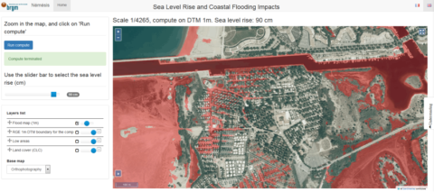
Scalable Interactive Platform for Geographic Evaluation of Sea-Level Rise Impact Combining High-Performance Computing and WebGIS Client
As the climate is changing, more applied information on resulting impacts are required to inform adaptation planning . Over the last decade, the amount of information relevant to climate change impact assessment has grown drastically. This can particularly be illustrated in coastal areas, threatened by sea-level rise due to climate change, where a key recent development has been the delivery of precise and accurate topography obtained by Light Detection and Ranging (Li-DAR) at regional and national scales, i.e., respectively, large and small scales.
A. Tellez-Arenas, R. Quique, F. Boulahya, G. Le Cozannet, F. Paris, S. Le Roy, F. Dupros, F. Robida
Communicating Climate Change Information for Decision-Making