Filtrer les publications
Manual on sea level measurements and interpretation - Volume V - Radar gauges
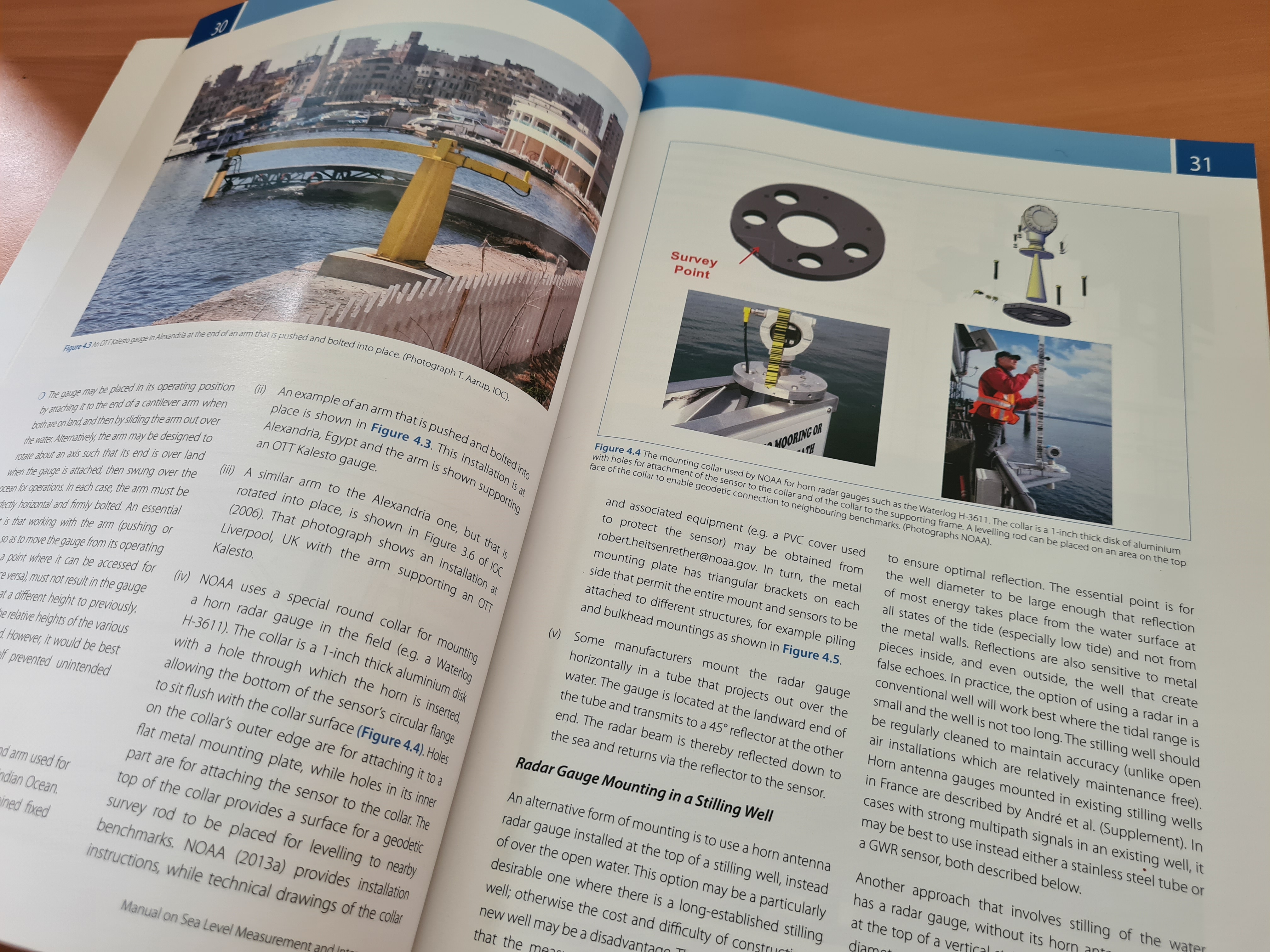
Radar water level sensors provide several advantages over the older water level instruments. They require less effort to install than float-well, bubbler, or pressure sensor systems. Radar sensors require less maintenance than traditional water-level sensors because they are not in contact with the water. Because radar is a “non-contact” measurement method, it is not susceptible to being obstructed by sediment or debris and does not require that sediment be flushed from a stilling well. Radar water-level sensors may not work at all sites.
Commission océanographique intergouvernementale
UNESCO
Satellite radar altimetry water elevations performance over a 200 m river: Evaluation over the Garonne River
For at least 20 years, nadir altimetry satellite missions have been successfully used to first monitor the surface elevation of oceans and, shortly after, of large rivers and lakes. For the last 5–10 years, few studies have demonstrated the possibility to also observe smaller water bodies than previously thought feasible (river smaller than 500 m wide and lake below 10 km2). The present study aims at quantifying the nadir altimetry performance over a medium river (200 m or lower wide) with a pluvio-nival regime in a temperate climate (the Garonne River, France).
S. Biancamaria, F. Frappart, A.-S. Leleu, V. Marieu, D. Blumstein, J.-D. Desjonquères, F. Boy, A. Sottolichio, A. Valle-Levinson
Advances in Space Research, volume 59

Reconstruction de la série marégraphique de Saint-Nazaire
Le projet relatif à la reconstruction et au contrôle de la série analogique des hauteurs d’eau observées à Saint-Nazaire, financé par le MEEM, la région Pays de Loire et par le Shom, a débuté le 19 août 2013. Cette étude s’inscrit dans le cadre du programme international GLOSS (Global Sea Level Observing System) de la Commission océanographique intergouvernementale (COI) de l’UNESCO et du SOERE – SO SONEL.
Y. Ferret
Shom
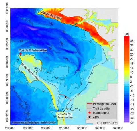
Analyse des mécanismes d'érosion le long du passage du Gois, Vendée
Le Passage du Gois est une chaussée submergée à chaque marée. Il permet de relier le continent à l’île de Noirmoutier à marée basse en traversant la Baie de Bourgneuf. L’érosion constatée le long de la chaussée côté Sud remet en cause sa pérennité. Une analyse des processus hydro-sédimentaires à l’origine de cette érosion a été réalisée pour la DREAL Pays-de-la-Loire dans le cadre d’un projet de classement du site. Le Gois est à l’origine une édification sédimentaire issue d’un hydrodynamisme particulier dans la baie.
B. Le Mauff, B. Waeles
Paralia - XIVèmes Journées Nationales Génie Côtier - Génie Civil, Toulon
Lagoon islets as indicators of recent environmental changes in the South Pacific - the New Caledonian example
The question of the impacts of climate change and sea level rise on small islands is currently much discussed. The many thousands of Pacific islands in their different contexts (geodynamic, climatic, etc.) and the insufficient data available explain why it is difficult to clearly discern the specific role of climate change in the recent evolution of these islands. To address this question, we investigated the recent changes affecting 21 islets in New Caledonia's lagoon.
M. Garcin, M. Vendé-Leclerc, P. Maurizot, G. Le Cozannet, B. Robineau, A. Nicolae-Lerma
Continental Shelf Research, volume 122
Temporal fluctuations in the trophic role of large benthic sulfur bacteria in mangrove sediment
Filamentous sulfur bacteria of the genus Beggiatoa form large mats covering the sediment in the shallow waters of a Guadeloupean mangrove (French West Indies). The abundance of these bacteria varies over the year and their trophic role may, therefore, also vary. We investigated this variation by conducting a survey examining the stable isotopic compositions of four grazers and four food sources during nine sampling sessions in three different periods of the year.
P.-Y. Pascal, O. Gros, H. T. S. Bischker
Food Webs, volume 7

Spécifications générales d’une station de surveillance marégraphique
Une station marégraphique ou station de surveillance du niveau de la mer doit permettre de suivre, en continu et sur une échelle de temps de plusieurs années, les variations du niveau de la mer, à différentes fréquences.
V. Donato
Shom
Hail observations and hailstorm characteristics in Europe: a review
Severe thunderstorms associated with large hail are among the most important perils in several European regions. Due to the local-scale extent of hail-affected areas and a lack of appropriate observing systems in most regions, hailstorms are not captured accurately and comprehensively, which makes statistical analysis of their frequency or climatology more difficult. Various studies have been conducted so far to describe and analyze the frequency of hailstorms or related impacts.
H.J. Punge, M. Kunz
Atmospheric Research, volumes 176-177
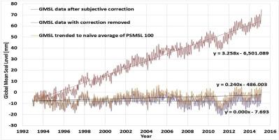
Coastal planning should be based on proven sea level data
There are two related measures of sea level, the absolute sea level, which is the increase in the sea level in an absolute reference frame, and relative sea level, which is the increase in sea level recorded by tide gauges. The first measure is a rather abstract computation, far from being reliable, and is preferred by activists and politicians for no scientific reason. For local and global problems it is better to use local tide gauge data. Proper coastal management should be based on proved measurements of sea level.
A. Parker, C. D. Ollier
Ocean & Coastal Management, volume 124