Filtrer les publications
Estimation des niveaux marins extrêmes avec et sans l’action des vagues le long du littoral métropolitain
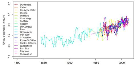
Pour caractériser le risque de submersion marine, il est très important d'avoir une connaissance précise des lois de distribution des niveaux d'eau marins, et plus particulièrement des niveaux d'eau extrêmes. En effet ce sont eux qui sont à l'origine des conséquences les plus dramatiques. Le programme de recherche mené au cours de cette thèse a été financé par le Ministère de l'Écologie, du Développement Durable et de l'Énergie.
X. Kergadallan
Laboratoire d'Hydraulique Saint-Venant - Université Paris-Est
Rapport technique final du projet NIVEXT - NIVeaux EXTrêmes
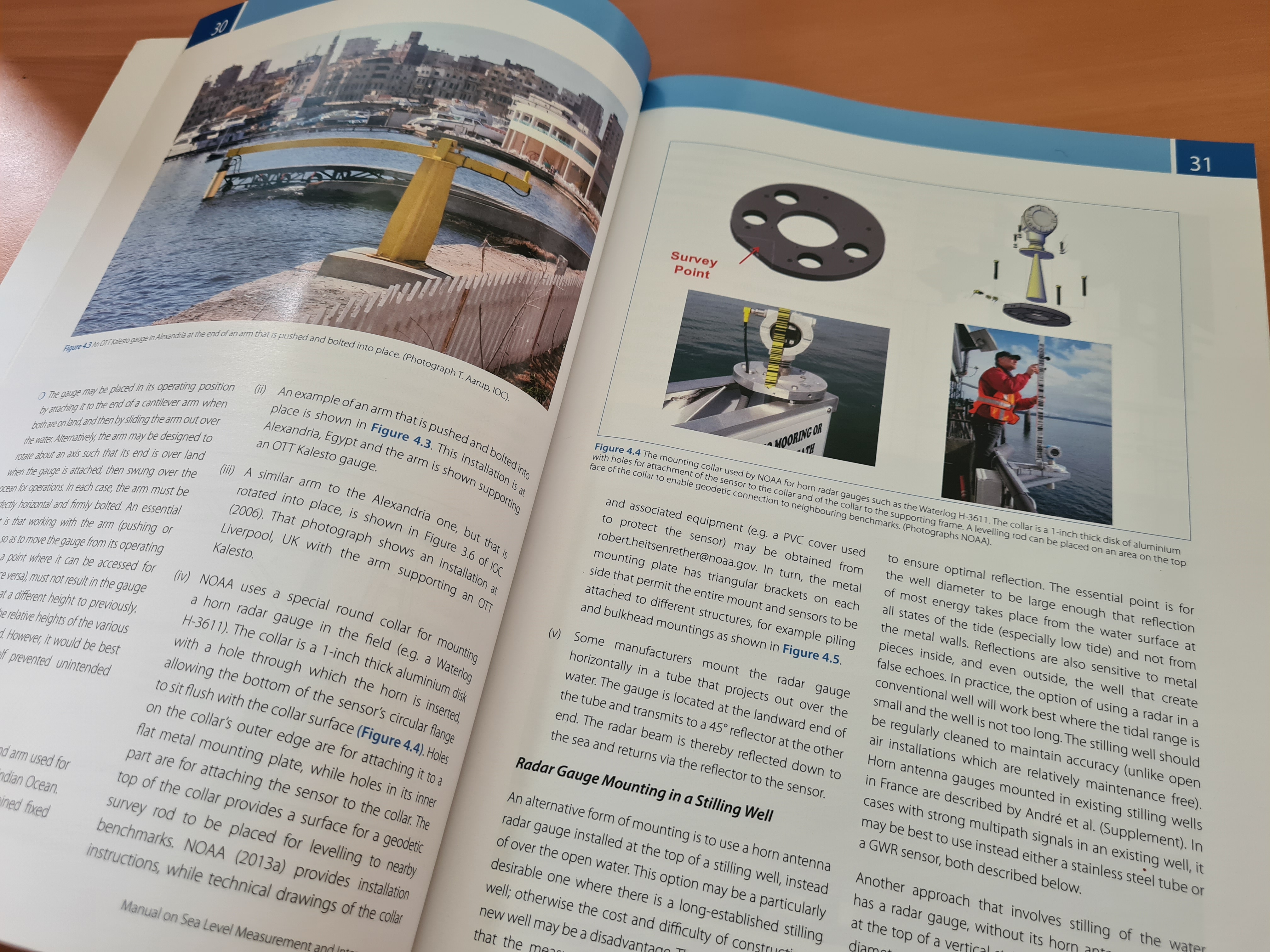
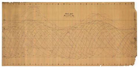
Ce rapport rend compte du travail effectué dans le cadre du projet NIVEXT financé par la DGPR. Le SHOM disposant de mesures marégraphiques sur les côtes françaises depuis 1850, en base de données numériques ou en dormance sous forme papier dans les archives, la possibilité d’établir un bilan de ce que ces données peuvent apporter à la connaissance des niveaux extrêmes est apparue une action nécessaire et cohérente avec la ligne portée par l’Etat.
C. Daubord
Shom
How historical information can improve estimation and prediction of extreme coastal water levels: application to the Xynthia event at La Rochelle (France)
The knowledge of extreme coastal water levels is useful for coastal flooding studies or the design of coastal defences. While deriving such extremes with standard analyses using tide-gauge measurements, one often needs to deal with limited effective duration of observation which can result in large statistical uncertainties. This is even truer when one faces the issue of outliers, those particularly extreme values distant from the others which increase the uncertainty on the results.
T. Bulteau, D. Idier, J. Lambert, M. Garcin
NHESS, volume 15

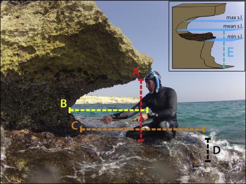
Tidal notches in Mediterranean Sea: a comprehensive analysis
Recent works (Evelpidou et al., 2012) suggest that the modern tidal notch is disappearing worldwide due sea level rise over the last century. In order to assess this hypothesis, we measured modern tidal notches in several of sites along the Mediterranean coasts. We report observations on tidal notches cut along carbonate coasts from 73 sites from Italy, France, Croatia, Montenegro, Greece, Malta and Spain, plus additional observations carried outside the Mediterranean.
F. Antonioli, V. Lo Presti, A. Rovere, L. Ferranti, M. Anzidei, S. Furlani, G. Mastronuzzi, P. E. Orru, G. Scicchitano, G. Sannino, C. R. Spampinato, R. Pagliarulo, G. Deiana, E. de Sabata, P. Sansò, M. Vacchi, A. Vecchio
Quaternary Science Reviews, volume 119
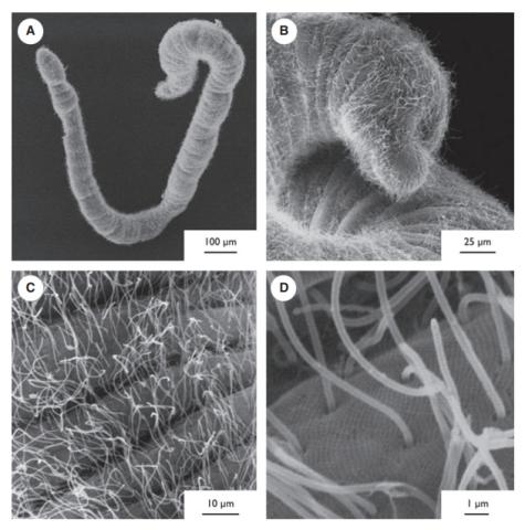
Diet of Haplognathia ruberrima (Gnathostomulida) in a Caribbean marine mangrove
Haplognathia ruberrima is a cosmopolitan gnathostomulid species found in sulfur bacterial mats in mangroves in Guadeloupe (French West Indies). Haplognathia ruberrima presents a δ13C value lower than all measured meiofaunal grazers and lower than the available measured food sources of this environment. This low δ13C value can not be due to specific ingestion of 13C-depleted methanogenic bacteria because abundances of those bacteria are reduced in surficial and deep sediments as revealed by δ13C of bacterial fatty acid.
P.-Y. Pascal, C. Bellemare, W. Sterrer, H. T. S. Boschker, S. Gonzalez-Rizzo, O. Gros
Marine Ecology, volume 36
Regional circulation around New Caledonia from two decades of observations
The regional and near-coastal circulation around New Caledonia is investigated using a compilation of more than 20 years of observations. Velocity profiles acquired by Shipboard Acoustic Doppler Current Profiler (SADCP) during 109 research cruises and ship transits since 1991 are analyzed and compared with absolute geostrophic currents inferred from hydrographic profiles and Argo floats drifts. In addition, altimetric surface currents are used to explore the variability of the circulation at various timescales.
S. Cravatte, E. Kestenare, G. Eldin, A. Ganachaud, J. Lefèvre, F. Marin, C. Menkes, J. Aucan
Journal of Marine Systems, volume 148
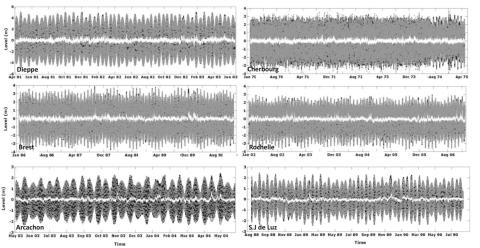
A new hybrid model for filling gaps and forecast in sea level: application to the eastern English Channel and the North Atlantic Sea (western France)
This research is carried out in the framework of the program Surface Water and Ocean Topography (SWOT) which is a partnership between NASA and CNES. Here, a new hybrid model is implemented for filling gaps and forecasting the hourly sea level variability by combining classical harmonic analyses to high statistical methods to reproduce the deterministic and stochastic processes, respectively.
I. Turki, B. Laignel, N. Kakeh, L. Chevalier, S. Costa
Ocean Dynamics, volume 65
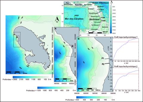
Modélisation des niveaux marins extrêmes associés à la circulation des cyclones Lenny (1999) et Omar (2008), commune de saint-pierre, littoral nord-ouest de la Martinique
Les submersions marines sont le plus souvent associées à des conditions météorologiques locales de tempête et aux phénomènes bien connus de surcote résultant du cumul de l’effet barométrique inverse et des vents d'afflux. Le déferlement des vagues joue également un rôle prépondérant dans la surélévation totale. Il provoque des variations du niveau d’eau de deux types : une surélévation statique du niveau moyen (surcote de vague) et des variations instantanées provoquées par le jet de rive. Ces deux phénomènes sont responsables dans certains cas de plus de 2/3 de la surélévation totale.
A. N. Lerma, Y.-F. Thomas, P. Saffache, P. Durand, M. Lamy
Vertigo, volume 14
The contribution of short-waves in storm surges: Two case studies in the Bay of Biscay
This study investigates the contributions of short waves in storm surges through the hindcast of two storms that hit the central part of the Bay of Biscay recently. Despite displaying comparable wind speed and directions in the study area, these two storms induced different storm surges and sea states. Xynthia (27–28th of February 2010) was characterized by large (up to 7 m significant wave height Hs) and short-period waves and induced an exceptional storm surge, locally larger than 1.6 m.
X. Bertin , K. Li, A. Roland, J.-R. Bidlot
Continental Shelf Research, volume 96