Filtrer les publications
How frequent is storm-induced flooding in the central part of the Bay of Biscay?
This study analyzes historical archives to produce a database of storm-induced coastal flooding in the French central part of the Bay of Biscay since 1500 AD. From this new database, 46 coastal floods have been reported for the last 500 years (1 event every 11 yr on average), which demonstrates the high vulnerability of this region to coastal flooding. The limitations of historical archives prevent concluding to a change in storminess over the period.
J.-F. Breilh, X. Bertin, E. Chaumillon, N. Giloy, T. Sauzeau
Global and Planetary Change, volume 122

REFMAR : une coordination pour l’observation du niveau de la mer
Le SHOM est le référent national pour l'observation, la gestion et la diffusion des mesures in situ du niveau de la mer.
N. Pouvreau - Equipe REFMAR
Shom
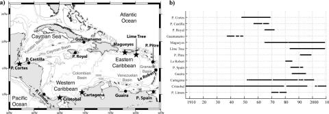
Sea level extremes in the Caribbean Sea
Sea level extremes in the Caribbean Sea are analyzed on the basis of hourly records from 13 tide gauges. The largest sea level extreme observed is 83 cm at Port Spain. The largest nontidal residual in the records is 76 cm, forced by a category 5 hurricane. Storm surges in the Caribbean are primarily caused by tropical storms and stationary cold fronts intruding the basin. However, the seasonal signal and mesoscale eddies also contribute to the creation of extremes.
R. R. Torres, M. N. Tsimplis
JGR Oceans, volume 119
Improving the estimation of extreme sea levels by a characterization of the dependence of skew surges on high tidal levels
The knowledge of the statistical distribution of extreme sea levels at the coast is of utmost importance for the characterization of flood risks in coastal areas. In this study we consider that the sea level results from two components: the (astronomical) tide and the (meteorological) surge, without considering the effects of waves. We focus our attention on the dependence of the surge height on the tidal level. At sites with a strong tidal range, the classical analysis methods rely on working only with high tide data (namely high tidal levels and skew surges).
X. Kergadallan, P. Bernardara, M. Benoit, C. Daubord
Proceedings of 34th Conference on Coastal Engineering, Seoul, Korea
Applying POT methods to the Revised Joint Probability Method for determining extreme sea levels
Newly exposed concepts of POT declustering (Bernardara et al., 2014) within the GPD-Poisson model are applied to the joint probability of tide and surge for determining extreme sea levels, as a variation of the Revised Joint Probability Method (RJPM, Tawn and Vassie, 1989). A mixture model is proposed for the meteorological residual (surge) component with a non-parametric (empirical) density for the bulk values and parametric models for both the lower and upper tails.
F. Mazas, X. Kergadallan, P. Garat, L. Hamm
Coastal Engineering, volume 91

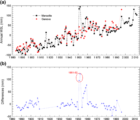
Rescue of the historical sea level record of Marseille (France) from 1885 to 1988 and its extension back to 1849–1851
This paper describes the historical sea level data that we have rescued from a tide gauge, especially devised originally for geodesy. This gauge was installed in Marseille in 1884 with the primary objective of defining the origin of the height system in France. Hourly values for 1885–1988 have been digitized from the original tidal charts. They are supplemented by hourly values from an older tide gauge record (1849–1851) that was rediscovered during a survey in 2009. Both recovered data sets have been critically edited for errors and their reliability assessed.
G. Wöppelmann, M. Marcos, A. Coulomb, B. Martín Míguez, P. Bonnetain, C. Boucher, M. Gravelle, B. Simon, P. Tiphaneau
Journal of Geodesy, volume 88
New insights on the tsunami recording of the May, 21, 2003, Mw 6.9 Boumerdès earthquake from tidal data analysis
We analyzed sea level data from a set of tide gauge stations located in the central and western Mediterranean Sea, that recorded the tsunami generated by the Mw 6.8 Boumerdès earthquake striking the coast of Algeria on May 21, 2003. This earthquake caused more than 2200 victims and thousands of injured. The causative fault was located a few kilometers offshore and during the rupture a tsunami was triggered. Waves were felt along a large part of the western and northern Mediterranean coasts, and in the Balearic islands waves higher that 2 m were measured.
A. Vecchio, M. Anzidei, V. Carbone
Journal of Geodynamics, volume 79

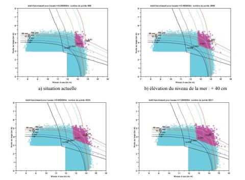
Évolution des périodes de retour des évènements franchissant avec le changement climatique
L'une des conséquences du changement climatique est la remontée du niveau moyen des mers. C'est cette conséquence qui est prise pour hypothèse principale dans ce travail. La méthode utilisée pour déterminer l'évolution des franchissements s'appuie sur deux sites d'études sur le littoral français : Deauville et Saint Malo.
G. Prevot, X. Kergadallan, P. Sergent
La Houille Blanche, volume 100
Ces tempêtes extrêmes que l'histoire ne nous a pas encore dévoilées
Les études d'aléa de submersion marine s'attachent à définir des valeurs extrêmes pour les niveaux marins et les houles et à combiner ces valeurs afin de produire un aléa de référence à la côte. Pourtant, ces phénomènes résultent souvent d'un même événement météorologique générateur : les tempêtes. Météo-France, le Cetmef et le Shom ont uni leurs efforts pour étudier les tempêtes menaçant le littoral breton et déterminer des événements extrêmes, dont on déduirait les paramètres hydrodynamiques pour l'étude des risques de submersion marine.
D. Goutx, F. Baraer, A. Roche, G. Jan
La Houille Blanche, volume 100