Filtrer les publications
Hyper-resolution mapping of regional storm surge and tide flooding: comparison of static and dynamic models
Storm tide (combination of storm surge and the astronomical tide) flooding is a natural hazard with significant global social and economic consequences. For this reason, government agencies and stakeholders need storm tide flood maps to determine population and infrastructure at risk to present and future levels of inundation. Computer models of varying complexity are able to produce regional-scale storm tide flood maps and current model types are either static or dynamic in their implementation.
J. A. Ramirez, M. Lichter, T. J. Coulthard, C. Skinner
Natural Hazards
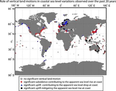
The key role of vertical land motions in coastal sea level variations: A global synthesis of multisatellite altimetry, tide gauge data and GPS measurements
This study aims to quantify the vertical motions driving the decadal coastline mobility and their uncertainty at global scale. Multisatellite altimetry is combined with tide gauges and Global Positioning System (GPS) observations to evaluate the marine and crustal components of relative sea level variations. Vertical land motions and sea level variations are estimated simultaneously over the past 20 years for a network of 886 ground stations, with accuracies better than 1.7 mm/yr.
J. Pfeffer, P. Allemand
Earth and Planetary Science Letters, volume 439
Estimation of insurance-related losses resulting from coastal flooding in France
A model has been developed in order to estimate insurance-related losses caused by coastal flooding in France. The deterministic part of the model aims at identifying the potentially flood-impacted sectors and the subsequent insured losses a few days after the occurrence of a storm surge event on any part of the French coast. This deterministic component is a combination of three models: a hazard model, a vulnerability model, and a damage model.
J. P. Naulin, D. Moncoulon, S. Le Roy, R. Pedreros, D. Idier, C. Oliveros
NHESS, volume 16
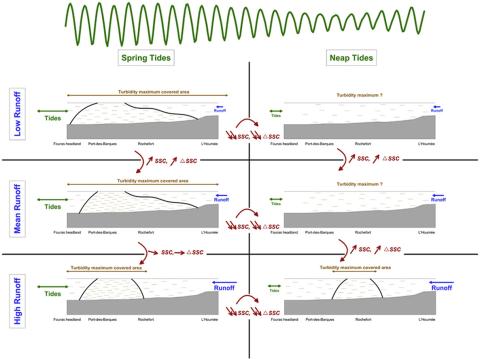
Formation and structure of the turbidity maximum in the macrotidal Charente estuary (France): Influence of fluvial and tidal forcing
Understanding estuarine sediment dynamics and particularly turbidity maximum dynamics is crucial for the management of these coastal systems. Various processes impact the formation, movement and structure of the turbidity maximum. Several studies have shown that tidal asymmetry and density gradients are responsible for the presence of this suspended sedimentary mass.
F. Toublanc, I. Brenon, T. Coulombier
Estuarine, Coastal and Shelf Science, volume 169
Monitoring individual wave characteristics in the inner surf with a 2-Dimensional laser scanner (LiDAR)
This paper presents an investigation into the use of a 2-dimensional laser scanner (LiDAR) to obtain measurements of wave processes in the inner surf and swash zones of a microtidal beach (Rousty, Camargue, France). The bed is extracted at the wave-by-wave timescale using a variance threshold method on the time series. Individual wave properties were then retrieved from a local extrema analysis. Finally, individual and averaged wave celerities are obtained using a crest-tracking method and cross-correlation technique, respectively, and compared with common wave celerity predictors.
K. Martins, C. E. Blenkinsopp, J. Zang
Journal of Sensors, Sensors for Coastal Monitoring
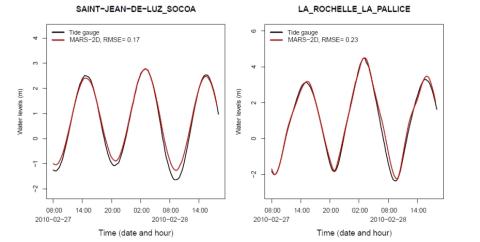
Determination of extreme sea levels along the Iberian Atlantic coast
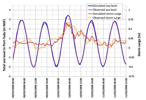
Extreme sea levels along the Atlantic Iberian coast are determined through the development and application of a numerical model for tides and surges, followed by a statistical analysis of the model results. A recent statistical method is assessed using 131 years of data from the Brest tide gauge, and the number of years of data required for an accurate statistical analysis is estimated. The statistical method is extended to consider tide–surge interactions, but they are shown to be small in the study region.
A. B. Fortunato, K. Li, X. Bertin, M. Rodrigues, B. Martín Míguez
Ocean Engineering, volume 111

Wave spectra partitioning and long term statistical distribution
A new method is presented for a physically based statistical description of wind wave climatology. The method applies spectral partitioning to identify individual wave systems (partitions) in time series of 2D-wave spectra, followed by computing the probability of occurrence of their (peak) position in frequency–direction space. This distribution can be considered as a spectral density function to which another round of partitioning is applied to obtain spectral domains, each representing a typical wave system or population in a statistical sense.
J. Portilla-Yandún, L. Cavaleric, G. Ph. Van Vledder
Ocean Modelling, volume 96
Coastal flooding of urban areas by overtopping: dynamic modelling application to the Johanna storm (2008) in Gâvres (France)
Recent dramatic events have allowed significant progress to be achieved in coastal flood modelling over recent years. Classical approaches generally estimate wave overtopping by means of empirical formulas or 1-D simulations, and the flood is simulated on a DTM (digital terrain model), using soil roughness to characterize land use. The limits of these methods are typically linked to the accuracy of overtopping estimation (spatial and temporal distribution) and to the reliability of the results in urban areas, which are places where the assets are the most crucial.
S. Le Roy, R. Pedreros, C. André, F. Paris, S. Lecacheux, F. Marche, C. Vinchon
NHESS, volume 15
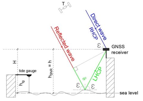
Sea level monitoring and sea state estimate using a single geodetic receiver
GNSS-Reflectometry (GNSS-R) altimetry has demonstrated a strong potential for sea level monitoring. Interference Pattern Technique (IPT) based on the analysis of the Signal-to-Noise Ratio (SNR) estimated by a GNSS receiver, presents the main advantage of being applicable everywhere by using a single geodetic antenna and receiver, transforming them to real tide gauges. Classical SNR analysis method used to estimate the variations of the reflecting surface height h(t) has a limited domain of validity due to its variation rate (dh/dt)(t) assumed to be negligible.
N. Roussel, G. Ramillien, F. Frappart, J. Darrozes, A. Gay, R. Biancale, N. Striebig, V. Hanquiez, X. Bertin, D. Allain
Remote Sensing of Environment, volume 171