Filtrer les publications
Historical Sea Level in the South Pacific from Rescued Archives, Geodetic Measurements, and Satellite Altimetry
Automatic sea-level measurements in Nouméa, South Pacific, started in 1957 for the International Geophysical year. Data from this location exist in paper record for the 1957–1967 period, and in two distinct electronic records for the 1967–2005 and 2005–2015 period. In this study, we digitize the early record, and established a link between the two electronic records to create a unique, nearly 60 year-long instrumental sea-level record. This work creates one of the longest instrumental sea-level records in the Pacific Islands.
J. Aucan, M. A. Merrifield, N. Pouvreau
Pure and Applied Geophysics, volume 174, pp3813–3823
Analyse des niveaux d'eau avec l'action des vagues au droit d'une plage de Méditerranée
La façade maritime méditerranéenne est bordée par plusieurs départements littoraux sur lesquels des enjeux de gestion du Domaine Public Maritime naturel (DPM) forts existent. La délimitation du DPM est complexe et un éventail de techniques est disponible. Afin d’apporter des éléments d’appréciation, le Cerema s’est penché sur l’approche probabiliste qui vise à estimer l’action des vagues au niveau du rivage à partir des données hydrauliques disponibles. Les périodes de retour associées au niveau d’eau avec l’action des vagues sont étudiées pour une plage à enjeux de Méditerranée.
X. Kergadallan, N. Metzler
Revue Paralia, volume 10
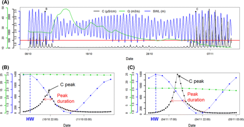
Short-term forecasting of saltwater occurrence at La Comté River (French Guiana) using a kernel-based support vector machine
Saltwater intrusion into rivers is a major concern for freshwater exploitation and management in French Guiana (South America). To detect and analyse saltwater occurrence, a permanent station was installed on La Comté River to measure the electrical conductivity C. The objective of the present study was twofold. First, the temporal link between C, sea water level SWL and river discharge Q was explored during the dry seasons from 2009 to 2012 (total measurement duration of ~6 months). A lag of 3 h between C and SWL was evidenced (i.e.
J. Rohmer, N. Brisset
Environmental Earth Sciences, volume 76
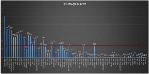
Homogenous regions based on extremogram for regional frequency analysis of extreme skew storm surges
To resist marine submersion, coastal protection must be designed by taking into account the most accurate estimate of the return levels of extreme events, such as storm surges. However, because of the paucity of data, local statistical analyses often lead to poor frequency estimations.
M. Andreewsky, S. Griolet, Y. Hamdi, P. Bernardara, R. Frau
NHESS, preprints
Towards a global higher-frequency sea level dataset
This paper describes the assembly of an updated quasi-global dataset of higher-frequency sea level information obtained from tide gauges operated by many agencies around the world. We believe that the construction of such a dataset is fundamental to scientific research in sea level variability and also to practical aspects of coastal engineering. A first version of the dataset was used in approximately a dozen published studies, and this second version is about twice the size, containing longer and more geographically representative sea level records.
P. L. Woodworth, J. R. Hunter, M. Marcos, P. Caldwell, M. Menéndez, I. Haigh
Geoscience Data Journal, volume 3

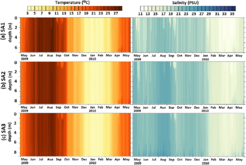
The effect of wind induced bottom shear stress and salinity on Zostera noltii replanting in a Mediteerranean coastal lagoon
The paper concerns the wind influence on bottom shear stress and salinity levels in a Mediterranean semi-enclosed coastal lagoon (Etang de Berre), with respect to a replanting program of Zostera noltii. The MARS3D numerical model is used to analyze the 3D current, salinity and temperature distribution induced by three meteorological, oceanic and anthropogenic forcings in this lagoon. The numerical model has been carefully validated by comparison with daily observations of the vertical salinity and temperature profiles at three mooring stations, for one year.
E. Alekseenko, B. Roux, D. Fougere, P. G. Chen
Estuarine, Coastal and Shelf Science, volume 187
A case study on the growth of Lanice conchilegas (Pallas, 1766) aggregations and their ecosystem engineering impact on sedimentary processes
Ecosystem engineers are organisms that modulate natural resources enabling the survival of other species. They drive environmental change and contribute to several coastal functional attributes such as landscape heterogeneity, sedimentary processes, and coastal protection. Our study focuses on the case of Lanice conchilega, a tube-building ecosystem engineer whose aggregations impact sedimentary processes. This polychaete forms biogenic tube aggregations distributed on the coasts of the northern hemisphere from the shallow intertidal to depths of 1900 m.
R. M. S. Alves, C. Van Colen, M. Vincx, J. Vanaverbeke, B. de Smet, J.-M. Guarini, M. Rabaut, T. J. Bouma
Journal of Experimental Marine Biology and Ecology, volume 489

Coastal applications from nadir altimetry: example of the X-TRACK regional products
In the coastal ocean zones, satellite altimetry data processing and interpretation poses specific difficulties, due to the interaction of the radar signal with land topography, inaccuracies in some of the geophysical corrections and to the fast changes in the sea level. In order to optimize the completeness and the accuracy of the sea surface height information derived from satellite altimetry in coastal ocean areas, a dedicated post-processing software, called X-TRACK, has been developed by the Center of Topography of the Ocean and Hydrosphere in Toulouse.
F. Birol, N. Fuller, F. Lyard, M. Cancet, F. Niño, C. Delebecque, S. Fleury, F. Toublanc, A. Melet, M. Saraceno, F. Léger
Advances in Space Research, volume 59

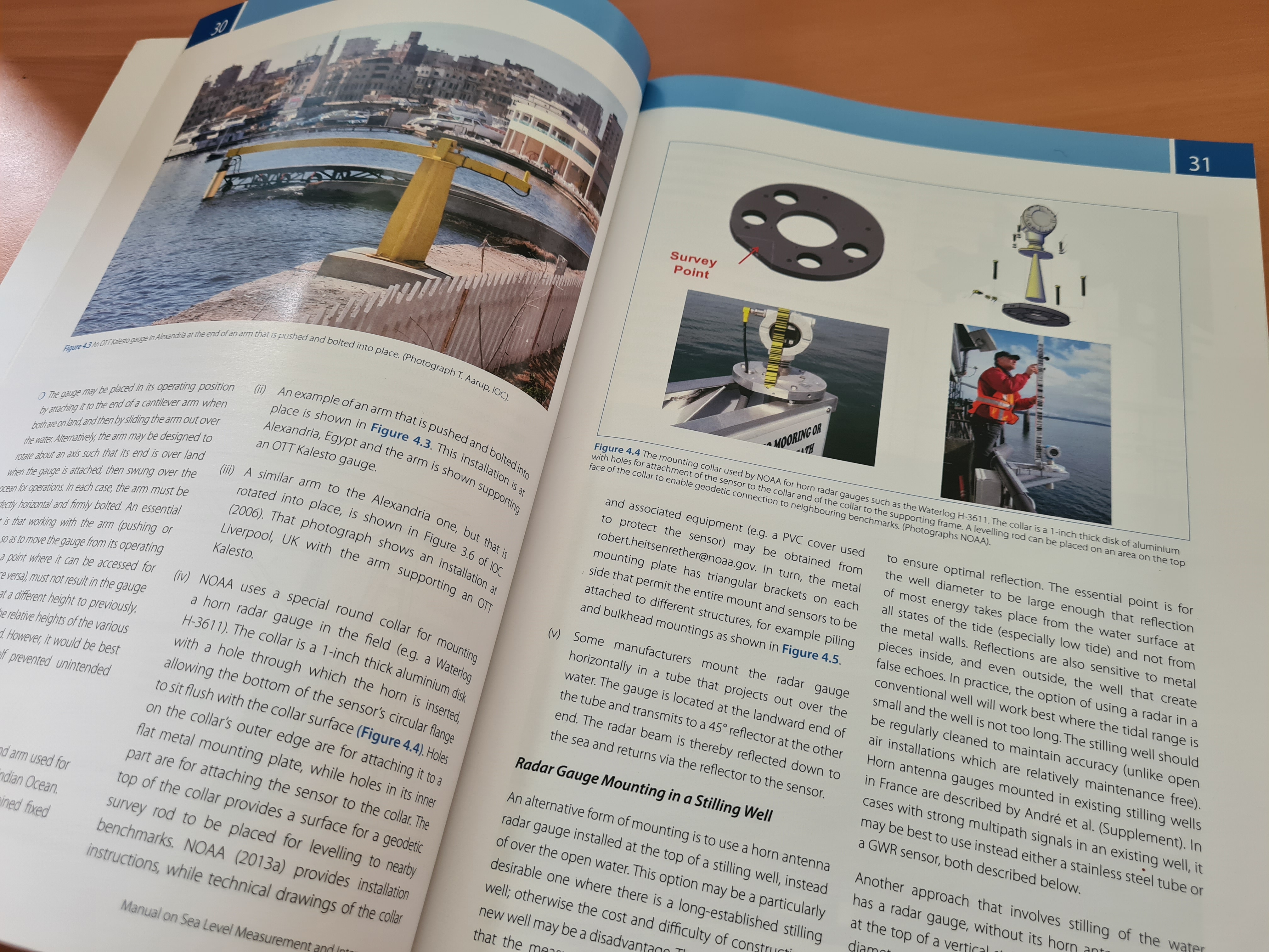
Manuel sur la mesure et l'interprétation du niveau de la mer - Volume V - Marégraphes radar
Le volume V est spécifiquement consacré aux marégraphes radar. Les télémètres radar sont utilisés depuis de nombreuses années dans les secteurs de l’industrie (afin de mesurer les niveaux des liquides dans les cuves) et de l’hydrologie (afin de mesurer le niveau des cours d’eau, des plans d’eau et des réservoirs).
Commission océanographique intergouvernementale
UNESCO