Filtrer les publications
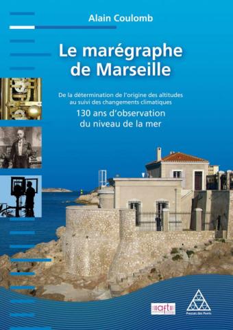
Le marégraphe de Marseille
Observatoire du niveau de la mer assez méconnu, le marégraphe de Marseille a été construit à la fin du XIXe siècle pour fixer le niveau zéro au-dessus duquel sont exprimées les altitudes du territoire français continental. Il abrite un instrument d’enregistrement, dit « marégraphe totalisateur », encore en parfait état de fonctionnement et aujourd’hui unique au monde dans sa catégorie.
A. Coulomb
AFT - Presses des Ponts
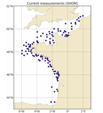
PREVIMER: Improvement of surge, sea level and currents modelling
The pre-operational system PREVIMER provides coastal observations and forecasts along French coasts. It provides, among other variables, currents, sea levels, surges and waves. This paper describes the development and validation of a high temporal (15 minutes) and spatial (250 m) resolution modeling system, based on MARS hydrodynamic model (Lazure and Dumas 2008), along the Atlantic and English Channel coasts.
L. Pineau-Guillou, F. Dumas, S. Theetten, F. Ardhuin, F. lecornu, J.-F. Le Roux, D. Idier, H. Muller, R. Pedreros
Mercator Ocean
Sea-level Science - Understanding Tides, Surges, Tsunamis and Mean Sea-Level Changes
Moving water has a special fascination, and the regular tidal movements of coastal seas must have challenged human imagination from earliest times. Indeed, the ancients who were able to link the regular movements of the sea to the movements of the sun and moon regarded tides as a tangible terrestrial manifestation of the powers of the celestial gods. For them the tides had religious significance; for us there are obviously many practical and scientific reasons for needing to know about and understand the dynamics of the oceans and coastal seas.
D. Pugh, P. Woodworth
Cambridge University Press

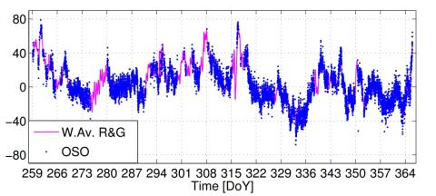
Sea level surges of June 2011 in the NE Atlantic Ocean: observations and possible interpretation
We present a synthesis of tide gauge data recorded on June 26–28, 2011, along the NE Atlantic and the English Channel coastlines, which show a significant sea level disturbance observed from Portugal to England during several hours. Though the amplitude was low (a few centimeters at most), the main disturbance was observed in about 30 harbors. The phenomenon started in south Spain and Portugal in the last hours of 26 June and reached the French west coastline on 27 June, at about noon.
A. Frère, C. Daubord, A. Gailler, H. Hébert
Natural Hazards, volume 74

Sea level time series and ocean tide analysis from multipath signals at five GPS sites in different parts of the world
We present sea level observations derived from the analysis of signal-to-noise ratio (SNR) data recorded by five coastal GPS stations. These stations are located in different regions around the world, both in the northern and in the southern hemisphere, in different multipath environments, from rural coastal areas to busy harbors, and experience different tidal ranges.
J. S. Löfgren, R. Haas, H.-G. Scherneck
Journal of Geodynamics, volume 80
Caractérisation de 7 évènements de tempête automne-hiver 2013-2014
Le littoral Atlantique-Manche-Mer du Nord a été balayé par une série de tempêtes assez remarquables cet automne-hiver 2013-2014 (Christian, Godehard, Xaver, Dirk, Petra) engendrant parfois des dégâts considérables. Les observations de niveau de la mer disponibles au SHOM ont été analysées pour caractériser ces événements. L’analyse des mesures marégraphiques, ainsi que l’exploitation des niveaux extrêmes calculés statistiquement, ont permis d’estimer les périodes de retour des niveaux marins atteints pendant ces événements, sur l’ensemble des côtes.
C. Daubord
Shom
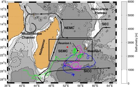
Circulation around La Réunion and Mauritius islands in the South-Western Indian Ocean: a modeling perspective
The objective of this study is to document the circulation in the vicinity of La Réunion and Mauritius islands, i.e., within 500 km offshore, on the intraseasonal time scale, using a high-resolution realistic modeling strategy. The simulated sea level anomalies, water mass properties, and large-scale circulation compare favorably with satellite and in situ observations. Our high-resolution simulation suggests that the currents around the islands are maximal locally, oriented southwestward, to the southeast of both islands which is not visible in low-resolution satellite observations.
S. Pous, P. Lazure, G. André, F. Dumas, I. Halo, P. Penven
JGR Oceans
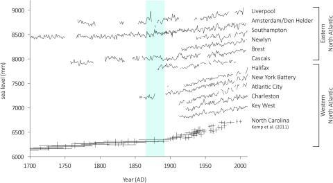
Contrasting records of sea-level change in the eastern and western North Atlantic during the last 300 years
We present a new 300-year sea-level reconstruction from a salt marsh on the Isle of Wight (central English Channel, UK) that we compare to other salt-marsh and long tide-gauge records to examine spatial and temporal variability in sea-level change in the North Atlantic. Our new reconstruction identifies an overall rise in relative sea level (RSL) of c. 0.30 m since the start of the eighteenth century at a rate of
A. J. Long, N. L. M. Barlow, W. R. Gehrels, M. H. Saher, P. L. Woodworth, R. G. Scaife, M. J. Brain, N. Cahill
Earth and Planetary Science Letters, volume 388
Effects of waves on coastal water dispersion in a small estuarine bay
A three-dimensional wave-current model is used to investigate wave-induced circulations in a small estuarine bay and its impact on freshwater exchanges with the inner shelf, related to stratified river plume dispersion. Modeled salinity fields exhibit a lower salinity surface layer due to river outflows, with typical depth of 1 m inside the bay. The asymmetric wave forcing on the bay circulation, related to the local bathymetry, significantly impacts the river plumes.
M. T. Delpey, F. Ardhuin, P. Otheguy, A. Jouon
JGR Oceans, volume 119