Filtrer les publications
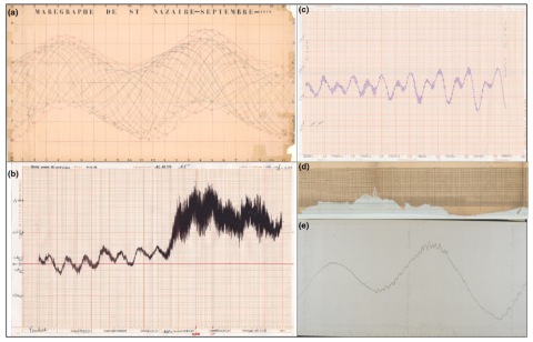
Seiches à l’échelle de baies : origines et identification des périodes propres d’oscillations à partir des données d’observations sur le long terme en Provence à partir du réseau HTM-NET
L’étude présentée sur les oscillations résonantes dans des bassins semi-ouverts de la côte provençale est basée sur l’analyse des données de niveaux issus de stations du réseau d’observation HTM-NET, composées de deux capteurs piézométriques, l’un immergé et l’autre émergé, permettant de connaitre la pression atmosphérique, le niveau d’eau et la température avec une période d’échantillonnage de 2 min. Elle concerne les baies de La Ciotat, de Sanary, la Rade de Toulon (grande et petite rades), le Golfe de Giens et la Rade d’Hyères.
V. Rey , C. Paugam, C. Dufresne, D. Mallarino, T. Missamou, J.-L. Fuda
Paralia - XVIIèmes Journées Nationales Génie Côtier – Génie Civil, Chatou
Sea level changes: the data available at the PSMSL and SONEL and the results of satellite altimetry
Sea level changes are a complex and quite discussed topic in the media, mostly because of their relationship with “climate change”. The first instruments to evaluate sea level changes are the Tide Gauges (TG) that began to register data in 1700, at Amsterdam. The TG registrations are validated and homogenized, to be comparable, by PSMSL (Permanent Service for Mean Sea Level). The longest record is the one in Brest (France) that begins in 1807. They register the Relative Sea Level (RSL). In fact, the data show that the vertical movements on the continent strongly affect the RSL curves.
M. A. Araújo
Research Square - Preprint
Data rescue process in the context of sea level reconstructions: An overview of the methodology, lessons learned, up-to-date best practices and recommendations
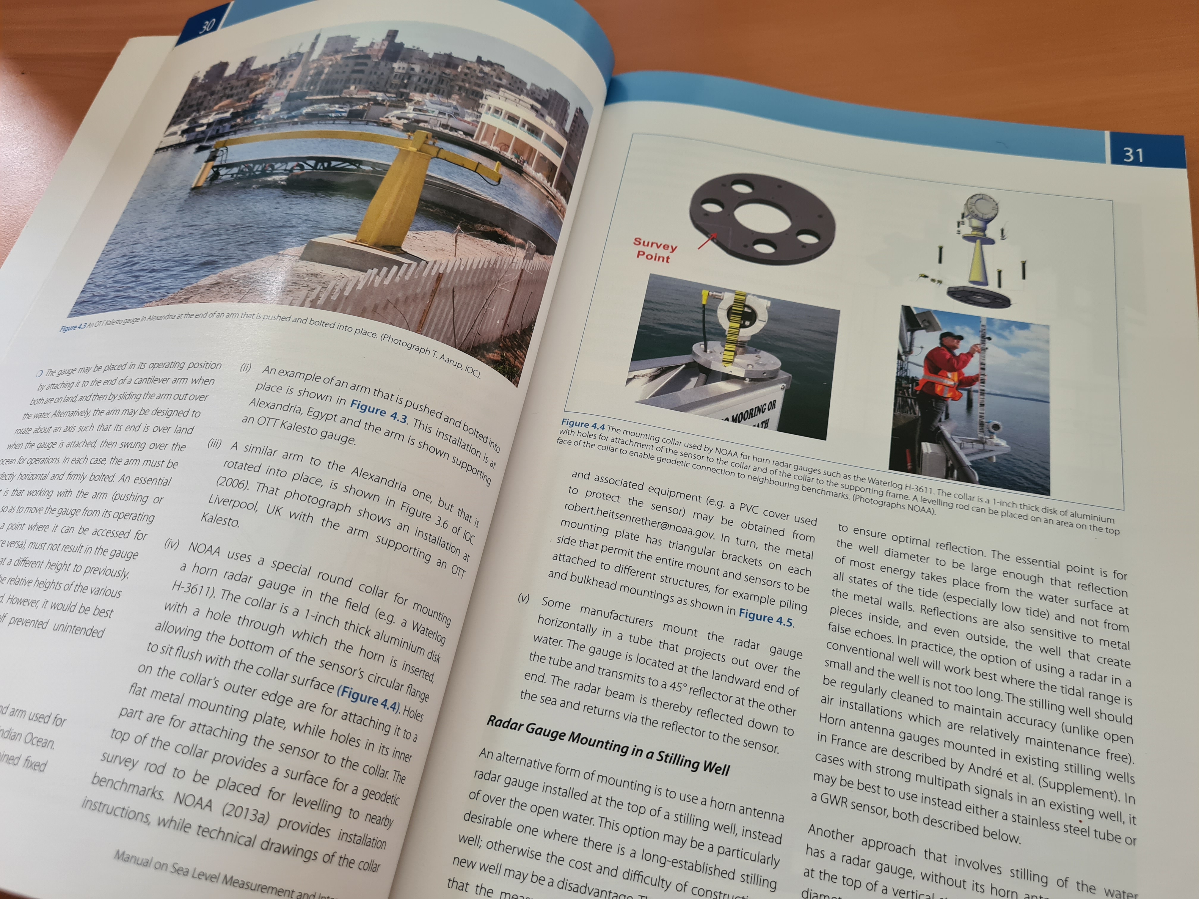
Coastal water level measurements represent one of the earliest geophysical measurements and allow an assessment of historical sea level rise and trends in tides, river flow and storm surge. However, recovery and digitization of archival tidal records have been much less widespread and systematic than, for example meteorological records. In this contribution, we discuss data rescue efforts and lessons learned in France, the United States and the United Kingdom, countries with early and extensive tide gauge networks by the mid-19th century.
A. Latapy, Y. Ferret, L. Testut, S. Talke, T. Aarup, F. Pons, G. Jan, E. Bradshaw, N. Pouvreau
Geoscience Data Journal, volume 10
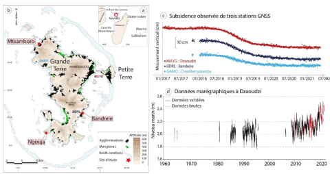
Apport de l'imagerie satellitaire pour l'identification et la cartographie des habitats littoraux de Mayotte soumis à une subsidence rapide
L’île de Mayotte (canal du Mozambique), offre une grande diversité de littoraux influencés par son vaste complexe récifo-lagonaire. Ces habitats (plages, platiers coralliens, herbiers, mangroves…) remplissent des fonctions écologiques reconnues : protection contre l’érosion côtière, consommation du CO2 atmosphérique, zone critique de biodiversité.
A. Aubry, A. Tempere
Paralia - XVIIèmes Journées Nationales Génie Côtier – Génie Civil, Chatou
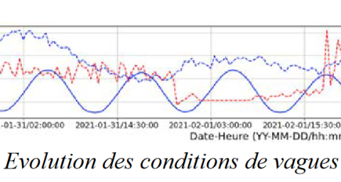
Etude de l'impact d'une tempête extrême sur la Grande Plage de Biarritz en présence d'une digue amovible en sacs de sable
La Grande Plage de Biarritz a connu plusieurs événements de tempêtes extrêmes ces dernières décennies qui ont causé d’importants dégâts matériels sur les ouvrages et bâtiments situés en front de mer. Ces événements ont conduit à la mise en place d’une stratégie de protection des infrastructures et des usagers qui intègre notamment le déploiement d’une digue amovible en sacs de sable sur le perré situé en haut de plage.
M. Rozki, D. Morichon, M. Delpey, V. Roeber, S. Abadie
Paralia - XVIIèmes Journées Nationales Génie Côtier – Génie Civil, Chatou
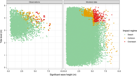
Bayesian networks to predict storm impact using data from both monitoring networks and statistical learning methods
Bayesian networks are probabilistic graphical models that are increasingly used to translate hydraulic boundary conditions during storm events into onshore hazards. However, comprehensive databases that are representative of the extreme and episodic nature of storms are needed to train the Bayesian networks. Such databases do not exist for many sites and many Bayesian networks are trained on data generated by process-based models. To our knowledge, they have not been trained exclusively on observational data for storm impact modeling.
A. Callens, D. Morichon, B. Liquet
Natural Hazards, volume 115
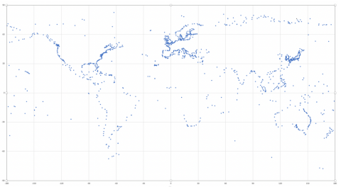
A database for sea-level monitoring in French Polynesia
This article presents a curated database of the sea-level measurements acquired by the network of the five geodetic tide gauges managed over French Polynesia by the Geodesy Observatory of Tahiti from 13 June 2009 to 28 January 2021.
J.-P. Barriot, F. Zhang, B. Ducarme, G. Wöppelmann, G. André, A. Gabillon
Geoscience Data Journal, volume 10
Technical note: On seasonal variability of the M₂ tide
Seasonal variability of the M₂ ocean tide can be detected at many ports, perhaps most. Examination of the cluster of tidal constituents residing within the M₂ tidal group can shed light on the physical mechanisms underlying seasonality. In the broadest terms these are astronomical, frictional–advective interactions, and climate processes; some induce annual modulations and some semiannual, in amplitude, phase, or both. This note reviews how this occurs and gives an example from each broad category.
R. D. Ray
Ocean Science, volume 18
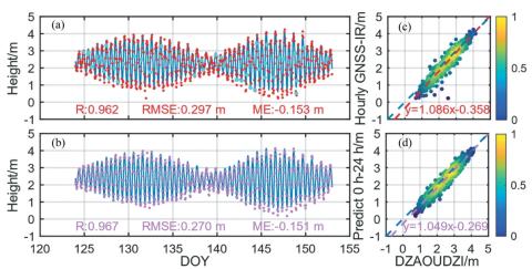
Hourly sea level height forecast based on GNSS-IR by using ARIMA model
Multi-satellite and Multi-Signal-to-Noise Ratio (SNR) types provide more basic data for the monitoring of sea level height by Global Navigation Satellite System Interferometric Reflectometry (GNSS-IR) technology. Few studies predict sea level height with high temporal resolution. This study proposes a theory based on GNSS-IR technology and Auto Regressive Integrated Moving Average (ARIMA) model. Taking the MAYG station as an example, the process of sea level height prediction and the determination of the best prediction scheme are shown.
N. Zheng, H. Chai, Y. Ma, L. Chen, P. Chen
International Journal of Remote Sensing, volume 43