Filtrer les publications
L’élévation du niveau de la mer et les risques côtiers
L’élévation du niveau de la mer est un processus qui s’est enclenché avec le réchauffement climatique d’origine humaine. Si ce phénomène ne peut plus être raisonnablement arrêté, sa vitesse dépendra des émissions de gaz à effet de serre et de la réponse des calottes de glace au réchauffement climatique. Ainsi, des politiques climat ambitieuses, limitant les émissions de gaz à effet de serre de manière massive et immédiate, peuvent apporter des bénéfices importants pour l’adaptation côtière en rendant possible de nombreuses options.
Gonéri Le Cozannet
Date de sortie 12/2023
Date de sortie 12/2023
XYZ n°177
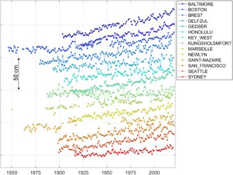
Reconstructions du niveau moyen global de la mer à partir de marégraphes
La longueur et la qualité des mesures du niveau de la mer produites par des marégraphes tels que ceux de Brest et de Marseille permettent d’envisager une reconstitution du niveau moyen global de la mer bien au-delà de l’ère des satellites de précision centimétrique initiée en 1992 avec la mission franco-américaine TOPEX/Poséidon. Certaines reconstructions remontent au XIXe siècle, mais la plupart démarrent au début du XXe siècle. Dans cet
Guy Wöppelmann
Date de sortie 12/2023
Date de sortie 12/2023
XYZ n°177
XYZ n°177 : Niveau de la mer
Dans ce numéro spécial, une collaboration de l'Association des amis du marégraphe de Marseille et de l'AFT, le lecteur pourra, lui-même, se faire une idée, aussi scientifique que précise, du phénomène. En effet, l'élévation de plus en plus rapide du niveau moyen de la mer est un des indicateurs des changements climatiques anthropiques. Ce numéro aborde donc, grâce à un panel de spécialistes, les techniques de la mesure, du marégraphe aux méthodes spatiales et GNSS puis les corrections de ces mesures pour les rendre indépendantes des mouvements terrestres.
G. André, A. Bailly, J. Chenal, A. Coulomb, B. Flacelière, C. Galpin, T. Landes, J.-P. Maillard, P. Sablayrolles, L. Testut, G. Wöppelmann, M. Ablain, E. Caillaud, C. Fraboul, N. Giloy, H. Hébert, N. Hesse, O. Jamet, D. Jourdan, D. Laplace, A. Latapy, ...
Date de sortie 12/2023
Date de sortie 12/2023
AFT

Des émissions de gaz à effet de serre à l’élévation du niveau de la mer : contraindre la dynamique du bilan d’énergie planétaire par la géodésie spatiale
Les émissions anthropiques de gaz à effet de serre conduisent à l’apparition d’une différence en haut de l’atmosphère entre le flux radiatif solaire reçu par la Terre et le flux radiatif infrarouge émis par la Terre. On appelle cette différence le déséquilibre énergétique planétaire, qui correspond à l’énergie additionnelle stockée par le système climatique. Le déséquilibre énergétique planétaire est donc la cause du réchauffement global.
Jonathan Chenal, Benoît Meyssignac
Date de sortie 12/2023
Date de sortie 12/2023
XYZ n°177
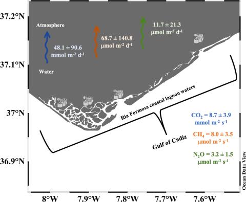
Dynamics of CO₂, CH₄, and N₂O in Ria Formosa coastal lagoon (southwestern Iberia) and export to the Gulf of Cadiz
A first characterization of greenhouse gases had been carried out to study their role and impact in a productive transitional coastal system of the southern Portugal – Ria Formosa lagoon. To this purpose, the partial pressure of CO₂ (pCO₂) and the concentration of dissolved CH₄ and N₂O have been measured. Two surveys were carried out during 2020, at low tide under typical conditions of Spring (March) and end of Summer (October).
A. Sierra, C. Correia, T. Ortega, J. Forja, M. Rodrigues, A. Cravo
Science of The Total Environment, volume 906
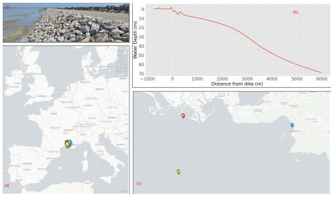
Sensitivity analysis of erosion on the landward slope of an earthen flood defence submitted to wave overtoppings
The study aims to provide a complete analysis framework applied to an earthen dike located in Camargue, France. This dike is regularly submitted to erosion on the landward slope that needs to be repaired. Improving the resilience of the dike calls for a reliable model of damage frequency.
C. Houdard, A. Poupardin, P. Sergent, A. Bennabi, J. Jeong
NHESS, volume 23
Estimation of skew surge uncertainties when predicting tides in the past
The study of storm surges and more generally of extreme events is a subject of growing interest in the current context of coastal risk management in a changing climate. Recent studies show that the consideration of past events improves statistical models. In this context, important investigations have been carried out in the last decade to retrieve and quantify water levels and skew surges associated with historical events for the 18th or 19th century.
N. Giloy, A. Latapy, G. André
Weather and Climate Extremes, volume 41
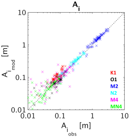
Atmospheric Wind and Pressure-Driven Changes in Tidal Characteristics over the Northwestern European Shelf
Understanding drivers of tidal change is a key challenge in predicting coastal floods in the next century. Whilst interactions between tides and atmospheric surges have been studied, the effects of wind and pressure on tides on an annual scale over the Northwestern European shelf have not been investigated. Here, a modelling approach using the shallow water MARS model is carried out to understand and quantify meteorological effects on tidal characteristics. The model setup is validated against the GESLA 3 tide gauge database.
J. Challis, D. Idier, G. Wöppelmann, G. André
Journal of Marine Science and Engineering
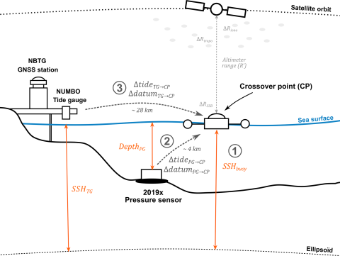
Nouméa: a new multi-mission calibration and validation site for past and future altimetry missions?
Today, monitoring the evolution of sea level in coastal areas is of importance, since almost 11 % of the world's population lives in low-lying areas. Reducing uncertainties in sea level estimates requires a better understanding of both altimetry measurements and local sea level dynamics. In New Caledonia, the Nouméa lagoon is an example of this challenge, as altimetry, coastal tide gauge, and vertical land motions from global navigation satellite systems (GNSSs) do not provide consistent information.
C. Chupin, V. Ballu, L. Testut, Y.-T. Tranchant, J. Aucan
EGU